
Wildfire Smoke Air Quality Monitoring: Detection, Communication, Protection
- May 22, 2026
- · 16 min read
- · Aethair Team
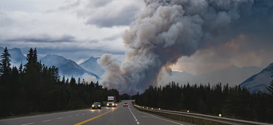
Wildfire smoke has become a continental air quality event. Plumes that used to stay regional now routinely reach the eastern half of the continent during a major fire season, and the operational consequences for outdoor workforces, indoor facilities, and public health agencies have grown with them. Canada’s 2023 fire season burned an estimated 15 million hectares according to Natural Resources Canada, with some estimates reaching as high as 18.4 million hectares per NASA Earth Observatory, affecting all thirteen provinces and territories at six to seven times the long-term annual average of roughly 2.5 million hectares. Smoke from those fires carried across most of North America and reached western Europe. The smoke from a fire in northern British Columbia or northern Quebec can degrade air quality in Toronto, Chicago, New York, and Philadelphia within days. Aethair’s own monitors recorded the impact at a station in New York during the June 2023 Quebec fire event, when AQI values across the US Northeast reached the Unhealthy, Very Unhealthy, and Hazardous categories, and Philadelphia briefly recorded its worst air quality readings in more than two decades (data from the event in our platform, video showing the event’s impact across New York and Philadelphia). For EHS managers responsible for outdoor workers, emergency response coordinators planning for evacuation and shelter, public health officials communicating exposure risk, and municipal and facility operators managing indoor air, wildfire smoke is now a recurring operational challenge that demands the same kind of measurement, documentation, and response infrastructure as any other major environmental hazard.
Wildfire smoke air quality monitoring is the practical foundation for that response. It answers three questions teams need answers to in real time: what is in the air, who is being exposed, and what should we do about it. This article covers what wildfire smoke contains, how Canadian and US air quality indices and workplace standards treat it, and how a monitoring program supports detection, communication, and protection across outdoor work sites, indoor facilities, and broader community networks.
What Is in Wildfire Smoke
Wildfire smoke is a complex mixture of solid particles, liquid droplets, and gases produced by the incomplete combustion of vegetation, structures, and the soils underneath them. The composition varies with fuel type, fire intensity, moisture, and the age of the plume as it travels downwind, but a few constituents are present at every scale and drive most of the health and visibility impacts.
Particulate matter dominates the public health concern. Wildfire smoke is rich in fine particulates, with the majority of mass concentrated in the PM2.5 fraction (particles 2.5 micrometers in aerodynamic diameter or smaller) and a meaningful share in PM1 (1 micrometer or smaller). These particles bypass the upper respiratory tract and reach the deep lung and bloodstream. PM10 (10 micrometers or smaller) is also elevated, particularly close to active fires, and contributes to visibility reduction, eye and airway irritation, and ash deposition on surfaces and water bodies. For deeper background on the health and regulatory framework around fine particulates, see our article on PM2.5 monitoring and regulatory standards.
Gases are part of the mixture from the start. Carbon monoxide (CO) is produced wherever fuel burns incompletely and is highest near the active fire front, on the fireline, and in confined areas like canyons and structure interiors. Nitrogen oxides (NOx), sulfur dioxide (SO2), and a wide range of volatile organic compounds (VOCs), including formaldehyde, acrolein, and benzene, are also present, and polycyclic aromatic hydrocarbons (PAHs) are produced when biomass burns. Carbon dioxide (CO2) is the largest gaseous output by mass and is a useful indicator of combustion activity even when other parameters are not directly measured.
Secondary pollutants form as the plume ages. Sunlight drives photochemical reactions between NOx and VOCs in the smoke that produce ground-level ozone (O3), which can elevate well above background levels hundreds of kilometers downwind of the source. Secondary organic aerosols also form, adding to the PM2.5 load far from the fire. This is why air quality alerts can rise sharply in cities that are nowhere near an active burn: the plume that arrives has had days to chemically transform.
A representative parameter set for a wildfire smoke monitoring program reflects this mix:
| Parameter | Why It Matters |
|---|---|
| PM2.5 | Primary health-driving pollutant; basis for AQI and AQHI alerts |
| PM1, PM10 | Ultrafine penetration; coarse fraction for visibility and dust |
| Carbon monoxide (CO) | Combustion proximity; firefighter and structure-fire risk |
| Carbon dioxide (CO2) | Combustion intensity; HVAC and indoor ventilation indicator |
| Total VOCs | Toxic gas burden; secondary ozone precursor |
| Nitrogen dioxide (NO2) | Combustion emissions; AQHI component |
| Ozone (O3) | Secondary pollutant in aged plumes |
| Wind speed and direction | Plume tracking, exposure attribution |
| Temperature, humidity, pressure | Sensor correction, fire behavior context |
How Air Quality Indices Treat Wildfire Smoke
Both Canada and the United States summarize air quality conditions for the public through a single composite index, and both indices respond to wildfire smoke primarily through their particulate matter inputs. The two systems are structured differently, and teams operating across the border benefit from understanding both.
Air Quality Health Index (AQHI), Canada
Environment and Climate Change Canada and Health Canada publish the Air Quality Health Index (AQHI), a scale calculated from 3-hour average concentrations of ground-level ozone, PM2.5, and nitrogen dioxide. It is reported on a 1 to 10+ scale grouped into four risk categories: Low (1 to 3), Moderate (4 to 6), High (7 to 10), and Very High (above 10). During wildfire smoke events, the PM2.5 contribution typically drives the index, and provincial agencies issue Special Air Quality Statements when the AQHI is forecast to reach the High range. Health Canada’s wildfire smoke guidance follows the standard AQHI health messages: at AQHI 7 to 10 (High), the general population is advised to consider reducing or rescheduling strenuous outdoor activity, and at-risk groups (children, older adults, pregnant individuals, and people with cardiovascular or respiratory conditions) are advised to reduce or reschedule strenuous activity outright; at AQHI above 10 (Very High), the general population is advised to reduce or reschedule, and at-risk groups to avoid strenuous outdoor activity entirely. Researchers in British Columbia have evaluated AQHI-Plus variants that respond more sensitively to short-term PM2.5 spikes typical of wildfire smoke, recognizing that the standard AQHI’s averaging structure can lag behind a fast-developing smoke event.
Air Quality Index (AQI), United States
The US Environmental Protection Agency publishes the Air Quality Index (AQI), a 0 to 500 scale with six categories: Good (0 to 50), Moderate (51 to 100), Unhealthy for Sensitive Groups (101 to 150), Unhealthy (151 to 200), Very Unhealthy (201 to 300), and Hazardous (301 to 500). The AQI is reported for each pollutant separately and the highest sub-index becomes the headline number. EPA revised the PM2.5 NAAQS in 2024, lowering the annual standard from 12.0 to 9.0 micrograms per cubic meter and adjusting several AQI breakpoints: AQI 50 now corresponds to 9.0 micrograms per cubic meter, and the upper-category breakpoints at AQI 200, 300, and 500 were lowered to 125.4, 225.4, and 325.4 micrograms per cubic meter respectively. The breakpoints at AQI 100 and 150 (35.4 and 55.4 micrograms per cubic meter) and the 24-hour PM2.5 NAAQS of 35 micrograms per cubic meter were retained. During wildfire smoke events, AirNow and state agencies typically report the NowCast AQI, which weights more recent hourly PM2.5 data to reflect rapidly changing conditions.
Reference Values to Keep in Mind
The World Health Organization’s 2021 air quality guideline sets an annual PM2.5 target of 5 micrograms per cubic meter and a 24-hour target of 15 micrograms per cubic meter, well below both Canadian and US regulatory standards. Reference values are useful context for indoor air quality programs and for organizations setting internal action thresholds below the regulatory minimum. The shorthand many monitoring teams use during a smoke event, applied loosely and adjusted for the 2024 AQI breakpoint revisions: PM2.5 above roughly 35 micrograms per cubic meter indicates a meaningful smoke impact, above 55 corresponds to AQI Unhealthy and typically pushes AQHI into the High range during smoke-dominated conditions, and above 125 (the post-2024 AQI 200 breakpoint) marks the threshold where outdoor activity should be curtailed for nearly everyone.
Regulatory and Workplace Frameworks
Wildfire smoke sits across several regulatory layers. There is no single North American rule, and many of the most consequential frameworks are issued by occupational health authorities rather than environmental ones.
Canada
The Canadian Centre for Occupational Health and Safety (CCOHS) directs employers to evaluate wildfire smoke risk in their hazard assessments, monitor the AQHI, maintain HVAC and filtration systems to limit indoor infiltration, and have written procedures for smoke events including evacuation criteria. Provincial occupational health authorities translate this into enforceable expectations. WorkSafeBC instructs employers to use the AQHI when scheduling outdoor work, reschedule or relocate work during peak smoke, provide NIOSH-approved respiratory protection such as N95 respirators with appropriate fit-testing where exposure cannot be otherwise controlled, and inspect HVAC systems and consider portable air cleaners with high-efficiency filters indoors. Alberta, Ontario, Manitoba, and Saskatchewan publish similar guidance through their respective occupational health and safety authorities. None of these frameworks specify a single numeric trigger across Canada, which makes a continuous, locally measured air quality record especially important for documenting employer due diligence.
United States
California’s Cal/OSHA section 5141.1, Protection from Wildfire Smoke, is the most prescriptive workplace wildfire smoke rule in North America and is widely referenced as a template by other jurisdictions. It applies when the current PM2.5 AQI is 151 or greater and employees may reasonably be exposed to wildfire smoke. At that trigger, employers must communicate the hazard, train employees, implement engineering and administrative controls where feasible to reduce exposure below an AQI of 151, and provide NIOSH-approved respirators (typically N95) for voluntary use. When the PM2.5 AQI exceeds 500, respirator use becomes mandatory. Washington (Chapter 296-820 WAC, effective January 2024) and Oregon (OAR 437-002-1081 for general industry and OAR 437-004-9790 for agriculture) have adopted analogous wildfire-smoke worker-protection rules, both with PM2.5 triggers lower than California’s: Washington requires training and response planning at PM2.5 of 20.5 micrograms per cubic meter, and Oregon makes respirator use mandatory at PM2.5 of 200.9 micrograms per cubic meter rather than California’s AQI-500 trigger. Federal OSHA does not have a wildfire-specific standard, but its General Duty Clause obligates employers to protect workers from recognized hazards, and OSHA references the AQI as a practical exposure indicator. NIOSH publishes additional guidance for wildland firefighters and outdoor workers, including respiratory protection selection and post-fire cleanup considerations.
For broader workplace exposure framework that governs on-site activity outside the smoke context, see our article on OSHA air quality standards and PEL compliance.
Detection, Communication, Protection: A Practical Wildfire and Smoke Monitoring Approach
A wildfire smoke monitoring program serves three operational purposes, and a well-designed program treats them as a connected sequence rather than three independent functions.
Detection
Detection is the measurement layer. The objective is to know, in real time and with calibrated confidence, what the air looks like at every location that matters. For an outdoor work site, that means a monitor at the work zone. For an industrial facility or warehouse, monitors at the perimeter and at relevant indoor locations. For a municipal program, a distributed network of sensors across neighborhoods, with coverage weighted toward vulnerable populations, outdoor public spaces, and major transportation corridors. PM2.5 is the anchor parameter; CO, VOCs, and meteorology round out the picture in contexts where proximity to active fire or secondary chemistry matters.
Three properties of the data determine whether it will support real decisions during a fast-moving event. First, continuity. Wildfire smoke conditions can change by an order of magnitude within an hour, and gaps in the record will be filled by assumption; continuous measurement at intervals of five to fifteen minutes is the practical minimum. Second, calibration traceability. Optical PM sensors drift, and a documented calibration history with periodic span and zero checks is what allows a reading to be defended as accurate. Third, contextual integrity. A PM2.5 number without supporting context is harder to act on. Wind direction, temperature, and humidity help a responder tell whether a local reading reflects nearby activity or a regional smoke layer that has arrived overhead, and a sufficiently dense network of monitors can map plume movement directly by observing how concentration peaks propagate from one location to the next, even when meteorological data is limited.
Communication
Detection without communication is wasted measurement. The communication layer translates sensor data into the messages, alerts, and dashboards that workers, the public, and decision-makers actually use.
For outdoor workforces, this means automated threshold alerts routed to supervisors and EHS leads by SMS, email, or webhook when AQHI or AQI thresholds are crossed, paired with documented response procedures. For emergency response coordinators, it means a live operational picture, often a map of monitor locations with current readings and trend arrows, that supports incident command decisions about resource staging, evacuation timing, and responder rotation. For public health and municipal officials, it means publicly accessible dashboards that show neighborhood-level conditions in language and units the public understands, and the ability to push notifications to vulnerable populations when conditions warrant.
At the regional scale, agencies also rely on satellite remote sensing to track smoke transport across the continent. NOAA’s GOES East and GOES West geostationary satellites and the Joint Polar Satellite System feed AerosolWatch products and AirNow.gov forecasts that show where plumes are moving over hours to days. NOAA’s analysis of the June 2023 Quebec fire event documented that more than 86 million people experienced fine particulate pollution above the federal health standard during that single episode, and similar satellite coverage continued through the 2025 season as fires in Manitoba, Saskatchewan, and Alberta sent smoke south into the United States. Satellite data sets the regional context. Ground-based monitoring networks fill in what satellites cannot resolve at street level: what people in a specific building, neighborhood, or work site are actually breathing.
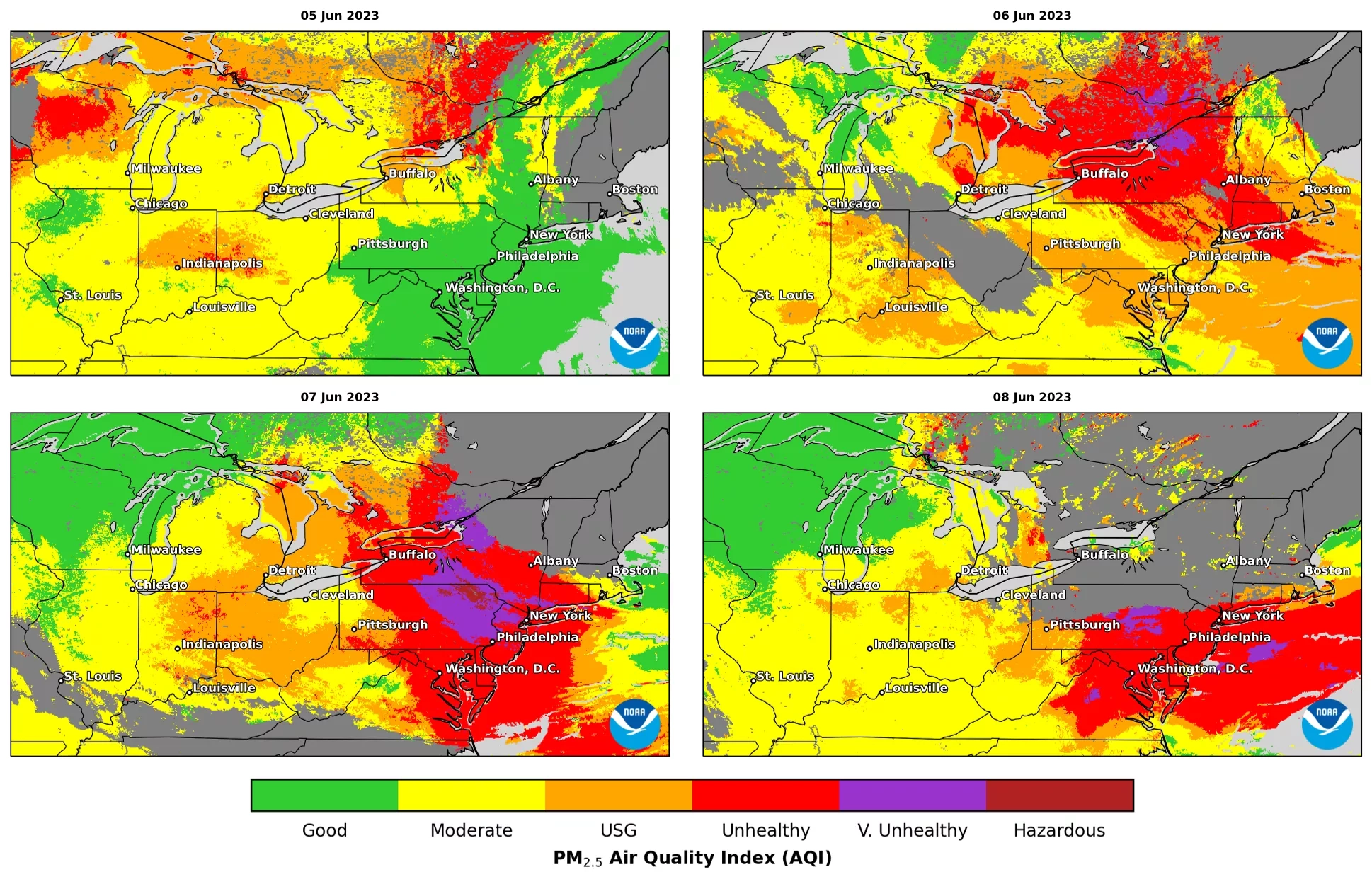
Daily mean PM2.5 across the eastern US, June 5 to 8, 2023, estimated from aerosol optical depth observed by NOAA's GOES-East ABI. "USG" is Unhealthy for Sensitive Groups. Image courtesy of NOAA NESDIS.
The credibility of the communication layer rests on the underlying record. Public-facing data that disagrees with regulatory monitors, or that updates inconsistently, erodes trust quickly. The same data infrastructure that supports operational alerts should be the source of public communication so that internal and external messages stay aligned. Aethair CEO Vasileios Nasis discussed how this plays out at the building level in his article on why air quality monitoring matters more than filtering alone, drawing on data from the 2023 event.
Protection
Protection is the action layer, and it splits cleanly into outdoor and indoor scenarios. Outdoors, the playbook follows the regulatory frameworks above: reschedule or relocate work, reduce exertion, provide and require properly fit-tested respirators when conditions warrant, and rotate exposed personnel. Indoors, the protection question is whether the building envelope and HVAC system are keeping the smoke out, and continuous indoor monitoring is what answers that.
A typical pattern during a smoke event: outdoor PM2.5 rises sharply, indoor PM2.5 lags but rises in proportion to the building’s air exchange rate and filtration efficiency. A facility with high-efficiency filtration and recirculation mode engaged should show a much smaller indoor rise than outdoor; a facility with leaky envelope or compromised filtration will show indoor levels approaching outdoor. The indoor-to-outdoor ratio measured during a smoke event is one of the most useful diagnostics a facilities team can have, and it directly informs filter upgrade decisions, portable air cleaner deployment, and HVAC operating procedures for future events. For broader context on indoor monitoring strategy, see our article on indoor air quality monitoring for EHS teams.
For projects with existing perimeter monitoring already in place, the wildfire monitoring layer often shares infrastructure with the operational perimeter program, with action levels and reporting reconfigured for the smoke event. Background on the perimeter monitoring approach is available in our article on perimeter air quality monitoring.
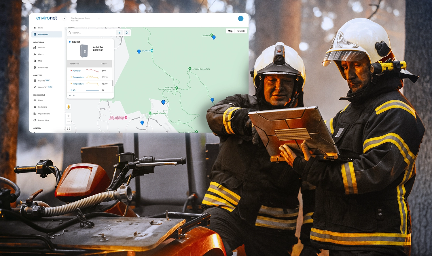
How Aethair PRO, Thiamis, and Environet Support Wildfire Response
Aethair PRO is built for the deployment patterns wildfire smoke monitoring demands: outdoor, often remote, often on short notice. Each unit continuously measures PM1, PM2.5, and PM10 and can be configured with two gas sensors selected from a list that includes carbon monoxide, carbon dioxide, nitrogen dioxide, sulfur dioxide, ozone, hydrogen sulfide, and total VOCs at ppb resolution, along with temperature, humidity, and barometric pressure. Units are pre-calibrated, housed in a rugged aluminum alloy enclosure for indoor or outdoor deployment, and transmit data over 4G LTE to Environet, so a fresh deployment can be online and reporting within minutes of installation. An optional solar power module supports locations without grid power, which matters for community network deployments and for staging during an active event.
Aethair IAQ complements the outdoor network on the indoor side. For hospitals, long-term care and skilled nursing facilities, schools, and other buildings serving sensitive populations, Aethair IAQ provides continuous indoor PM1, PM2.5, PM10, CO2, VOC, temperature, and humidity readings that let operators see how outdoor smoke is translating into indoor exposure in real time, and verify that HVAC adjustments, filter changes, and portable air cleaners are actually working.
Thiamis extends the network by integrating third-party instruments and existing site equipment into the same record. For organizations with weather stations, particulate samplers, or reference instruments already deployed, Thiamis brings every reading into one system of record. Adding a wind sensor through Thiamis alongside an Aethair PRO network gives responders the meteorological context to interpret what they are seeing: a PM2.5 spike with the wind shifting north tells a different operational story than a slow regional rise with calm conditions.
Environet is the operational layer. It shows data from every Aethair PRO, Aethair IAQ, and Thiamis device on a unified live map, displays PM, gas, and meteorological readings at each location with historical trend views, applies user-configured action levels against any monitored parameter, and routes alerts by email, SMS, or webhook. For a distributed deployment across a region, the live map shows how PM2.5 and other readings rise and fall at each station as a smoke event develops, giving emergency response and public health teams a shared real-time picture of which locations are most affected. The same data feeds public dashboards where transparency is part of the response.
Aethair Reports turn the continuous record into the documentation that follows a smoke event. Exposure summaries, exceedance logs against configured action levels, indoor-versus-outdoor diagnostics, and meteorologically contextualized data tables can be generated automatically and delivered as PDFs, web links, or scheduled emails. The same chain-of-custody record that supported real-time decisions becomes the post-event documentation for insurers, regulators, public health authorities, and internal review.
Noesis, Aethair’s AI analysis engine, layers natural-language analysis on top of the same record. Teams can ask Noesis to surface the locations and time windows where PM2.5 exceeded an action level during a multi-day event, identify which stations in a regional network saw the highest sustained concentrations as the plume moved through, or generate narrative event summaries without writing them by hand. For agencies and operations leaders making decisions across many sites at once, that turns hours of manual review into a few minutes of confirmation.
Across most of North America, wildfire smoke is now part of the standard environmental risk picture rather than an exceptional event. The teams that handle it best build their detection, communication, and protection program ahead of the season, using the same continuous, documented data infrastructure they apply to any other major environmental risk.
For background on the foundational science and regulatory framework around the primary pollutant in wildfire smoke, see our article on PM2.5 monitoring, health effects, and regulatory standards. For broader context on building a defensible compliance record from environmental data, see our article on EHS compliance reporting.